Land Management Status
 |
|
Our efforts here have been directed at bringing together several disparate data sets that contain the boundaries of public lands together into a single data set or coverage, and then reviewing each parcel of land and assigning a code to designate the level of protection afforded to biodiversity. In our analysis, we specifically used the term "stewardship" rather than "ownership" in recognition that legal ownership does not necessarily equate to the entity charged with management of the resource.
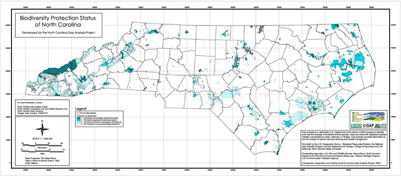
GAP currently uses a scale of 1 to 4 to categorize the degree of maintenance of biodiversity for each distinct land unit. A status of "1" denotes the highest, most permanent level of maintenance, and "4" represents no biodiversity protection or areas of unknown status. The characteristics used to determine status are as follows:
Permanence of protection from conversion of natural land cover to unnatural (human-induced barren, arrested succession, cultivated exotic-dominated).
Amount of the tract protected, with 5% allowance for intensive human use.
Inclusiveness of the protection, i.e., single feature such as wetland versus all biota and habitat.
Type of management program and degree that it is mandated or institutionalized.
The four status categories utilized can generally be defined as follows:
Status 1: An area having permanent protection from conversion of natural land cover and a mandated management plan in operation to maintain a natural state within which disturbance events (of natural type, frequency, and intensity) are allowed to proceed without interference or are mimicked through management.
Status 2: An area having permanent protection from conversion of natural land cover and a mandated management plan in operation to maintain a primarily natural state, but which may receive use or management practices that degrade the quality of existing natural communities.
Status 3: An area having permanent protection from conversion of natural land cover for the majority of the area, but subject to extractive uses of either a broad, low-intensity type or localized intense type. It also confers protection to federally listed endangered and threatened species throughout the area.
Status 4: Lack of irrevocable easement or mandate to prevent conversion of natural habitat types to anthropogenic habitat types. Allows for intensive use throughout the tract. Also includes those tracts for which the existence of such restrictions or sufficient information to establish a higher status is unknown.
|
|
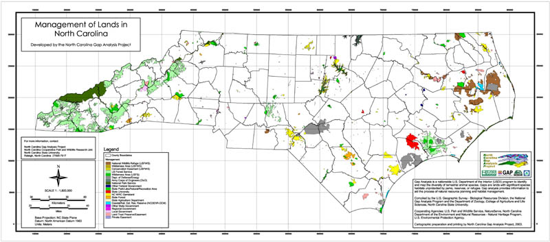
We mapped 2089 polygons of protected (Status 1, 2, or 3) lands in North Carolina totaling approximately 10% of the total area of the State. Public lands make up the vast majority of all protected areas at all Status levels. Federal land dominates the area of protected lands at the Status 1 and 3 levels due to large amounts of National Park Service land (primarily the Great Smoky Mountains National Park) and USFS Wilderness Areas considered to be Status 1 and USFS Multiple Use Areas considered to be Status 3. Federal Department of Defense properties make up 21% of Status 3 land. Land management units considered to be Status 2 are more evenly distributed between State and Federal agencies. Status 2 state lands are dominated by State Parks and WRC Game Lands, while Status 2 Federal lands are mostly USFWS Wildlife Refuges. Contributions to biodiversity protection from land trusts and other NGOs make up only 3% of total protected lands. However, we documented over 20,000 ha of NGO-managed land considered highly protected (Status 1 and 2) and over 37,000 ha of protected land (Status 1, 2, and 3).
The largest areas of protected land are located in the eastern and western portions of the state, where accessibility and agricultural productivity are often limited by excessive wetness or mountainous terrain. On the Coastal Plain ecoregion of eastern North Carolina, protected areas are mostly USFWS Wildlife Refuges, USDOD military bases, and the Croatan National Forest. In the mountainous west, protected areas are dominated by the Cherokee, Nantahala, and Pisgah National Forests and the Great Smoky Mountains National Park. The relatively few large protected areas in the Piedmont area of central North Carolina are upland U.S. Army Corps of Engineers lands surrounding man-made reservoirs and the highly fragmented Uwharrie National Forest.