
| Taxa: |
| Order: |
| Family: |
| Amphibia |
| Caudata |
| Amphiumidae |
| NatureServe Global Rank: |
| NatureServe State (NC) Rank: |
| G5 |
| S4 |
| Federal Status: |
| NC State Status: |
| --- |
| --- |
| Land Unit |
| US Fish & Wildlife Service |
| US Forest Service |
| US National Park Service |
| US Department of Defense |
| NC State Parks |
| NC University System |
| NC Wildlife Res. Com. |
| NC Forest Service |
| NC Div. of Coastal Mgmt. |
| Local Governments |
| Non-Governmental Org. |
| Other Public Lands |
| Private Lands |
| GAP Status 1-2 |
| All Protected Lands |
| Statewide |
| Hectares |
| 110,948.85 |
| 49,192.74 |
| 66,776.40 |
| 1,030.50 |
| 14,002.02 |
| 22,181.67 |
| 66,100.32 |
| 7,917.84 |
| 7,871.94 |
| 462.15 |
| 18,471.60 |
| 504.36 |
| 1,234,780.83 |
| 217,039.23 |
| 363,187.17 |
| 1,600,241.22 |
| Acres |
| 274,160.53 |
| 121,557.88 |
| 165,008.05 |
| 2,546.42 |
| 34,599.74 |
| 54,812.09 |
| 163,337.42 |
| 19,565.40 |
| 19,451.98 |
| 1,142.00 |
| 45,644.31 |
| 1,246.30 |
| 3,051,209.29 |
| 536,315.51 |
| 897,454.87 |
| 3,954,281.40 |
| % of Dist. on |
| Prot. Lands |
| 30.5 % |
| 13.5 % |
| 17.9 % |
| 0.3 % |
| 3.9 % |
| 6.1 % |
| 18.1 % |
| 2.2 % |
| 2.2 % |
| 5.1 % |
| 5.1 % |
| < 0.1 % |
| < 0.1 % |
| 59.8 % |
| ----- |
| ----- |
| % of Dist. on |
| All Lands |
| 6.9 % |
| 3.1 % |
| 4.2 % |
| < 0.1 % |
| 0.9 % |
| 1.4 % |
| 4.1 % |
| 0.5 % |
| 0.5 % |
| < 0.1 % |
| 1.2 % |
| < 0.1 % |
| 77.2 % |
| 13.6 % |
| ----- |
| ----- |
|
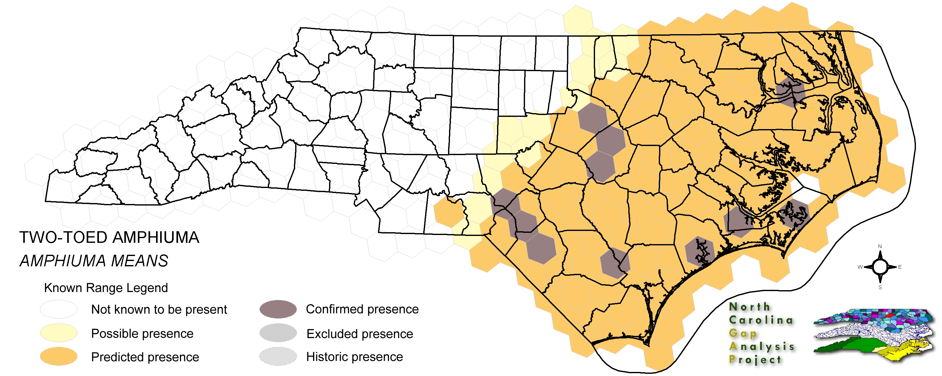
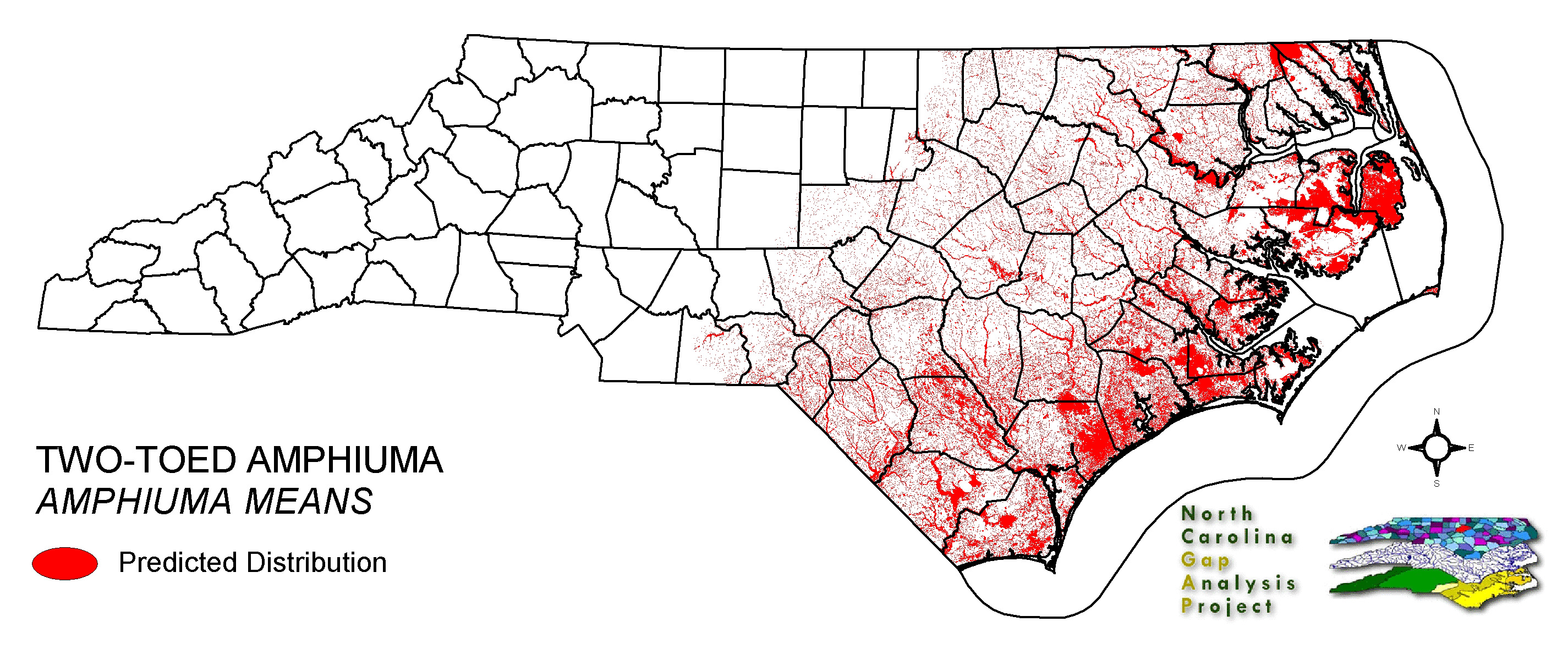
The two-toed amphiuma can be found a variety of lowland and even some isolated upland water bodies of the coastal plain. Specimens have been found on some barrier islands (Gibbons and Coker 1978) and in the sandhills subregion (Garton and Sill 1977). It is known predominantly as a species of blackwater swamps and river backbays. It typically seeks out still or slow-moving waters with mud bottoms and herbaceous littoral zones or abundant leaf litter and debris covering the substrate. It has the capability of moving overland, but is limited by terrain and distance to isolated ponds. Therefore, it is primarily found within bottomlands and among low lying wet sites at the margins of bottoms. Soft substrate or thick aquatic vegetation are important as burrowing sites. Eggs are laid at the bottom of seasonal ponds during drying periods. Eggs become encased in hardened mud until rains flood site and induce hatching. NATURE SERVE GLOBAL HABITAT COMMENTS: Swamps, bayous, margins of muddy sloughs, cypress heads, drainage ditches, sluggish streams, wet meadows, muddy lakes; soft substrate for burrowing or thick aquatic vegetation important for shelter. Often uses crayfish burrows. May leave water, especially on rainy nights; sometimes found under objects at water's edge. Eggs are laid under objects in damp place near water's edge or possibly in shallow water, or underground. |
| Code | Name | Description | NC Natural Heritage Program Equivalent |
| 121 | Maritime Pinelands | Loblolly forests and woodlands of the outer coastal plain. | Estuarine Fringe Loblolly Pine Forest |
| 17 | Maritime Forests and Hammocks | Maritime forests and woodlands dominated by live or sand laurel oak. Estuarine Fringe forests dominated by loblolly pine. | Coastal Fringe Evergreen Forest, Maritime Deciduous Forest, Maritime Deciduous Forest |
| 126 | Interdune Wooded Depression Swamp | Includes swamps dominated by sweetbay and swampbay or dogwood dominated forests. | Maritime Shrub Swamp, Maritime Swamp Forest |
| 380 | Coastal Plain Fresh Water Emergent | Emergent vegetation in fresh water seepage bogs, ponds and riverbeds of the coastal plain. Includes alliances dominated by sedges, eelgrass, as well as cane found in unforested cane-brakes. | Small Depression Pond, Sandhill Seep, Floodplain Pool, Unforested Floodplain Canebrake, Riverscour Prairies, Vernal Pools |
| 50 | Coastal Plain Mixed Bottomland Forests | Includes forests dominated by a variety of hardwood species, including sweetgum, cottonwood, red maple. | Coastal Plain Bottomland Hardwood (in part), Coastal Plain Levee Forest |
| 49 | Coastal Plain Oak Bottomland Forest | Bottomland forests dominated by deciduous oak alliances. Oaks represented can include swamp chestnut, cherrybark, willow, and/or overcup oak. Inclusions of loblolly pine temporarily flooded forests occur in patches. Hydrology is temporarily to seasonally flooded. | Coastal Plain Bottomland Hardwoods (in part) blackwater subtype, brownwater subtype |
| 158 | Coastal Plain Nonriverine Wet Flat Forests | Loblolly pine - Atlantic white-cedar - red maple - swamp tupelo saturated forests as well as forests dominated by loblolly, sweetgum, and red maple in non-riverine flats. | Non-riverine Wet Hardwood Forest |
| 41 | Peatland Atlantic White-Cedar Forest | Dense stands of Atlantic white cedar with saturated hydrology. Can include swamp tupelo, red maple, and pond pines with a moderate shrub and herb layer. | Peatland Atlantic White-Cedar Forest |
| 15 | Seepage and Streamhead Swamps | Includes extensive peat flats in the coastal plain, dominated by swamp tupelo, maples, and Atlantic white cedar alliances. In the sandhills includes streamhead pond pine and bay forests alliances. Saturated hydrology. | Bay Forest, Small Depression Pocosin, Streamhead Atlantic White Cedar Forest, Streamhead Pocosins |
| 30 | Cypress-Gum Floodplain Forests | Swamps dominated by black or swamp tupelo with or without Taxodium. Seasonally to semi-permanently flooded hydrology. | Cypress-Gum Swamps |
| 78 | Pond-Cypress - Gum Swamps, Savannas and Lakeshores | Cypress dominated swamps and lakeshores. Can include bays dominated by pond cypress or shorelines of coastal plain lakes with a narrow band of cypress. | Non-riverine Swamp Forest, Natural Lakeshores (in part) |
| 385 | Oak Bottomland Forest and Swamp Forest | The swamp chestnut oak, cherrybark oak, shumard oak and sweetgum alliance is one representative. Other alliances are dominated by water, willow, and overcup oaks. Swamp forests can be dominated by sweetgum, red maple, and black gum being dominant. Loblolly can occur in combination with sweetgum and red maple, or with tulip poplar. Includes saturated and semi- to permanently flooded forests in the mountains. | Piedmont/Mountain Bottomland Forest, Piedmont/Mountain Swamp Forest |
| 87 | Pocosin Woodlands and Shrublands | Includes pond pine woodland, low pocosin and high pocosin shrub dominated areas. Canebrakes and bay forests may be present. | Pond Pine Woodlands, Peatland Canebrake, Small Depression Pocosin |
| 67 | Wet Longleaf or Slash Pine Savanna | Wet flatwoods and pine savannas, typically dominated by longleaf pines, but slash or pond pines may be the dominant pines. | Wet Pine Flatwoods |
| 97 | Mesic Longleaf Pine | Longleaf pine woodlands without a major scrub oak component. Slash or loblolly pines may be present as well. | Mesic Pine Flatwoods |
| 238 | Piedmont/Mountain Submerged Aquatic Vegetation | Seasonally to permanently flooded areas with aquatic vegetation. Waterlily, pondweed, hydrilla smartweed are a few of the species that can occur. | Piedmont/Mountain Semipermanent Impoundment (in part) |
| 239 | Piedmont/Mountain Emergent Vegetation | Emergent vegetation of all wetland hydrologies. Sites would commonly support species such as tussock sedge, rushs, and cattail alliances. | Rocky Bar and Shore (in part) |
| 267 | Riverbank Shrublands | Riverside shrubs with temporarily flooded hydrologies. Found in the both the Mountains and Piedmont. Containing dominants such as smooth alder and a Carolina or black willows. | Sand and Mud Bar |
| 269 | Floodplain Wet Shrublands | Saturated shrublands of the Piedmont, includes buttonbush, swamp-loosestrife, decodon and alders. | Piedmont/mountain Semipermanent Impoundment |
| 384 | Piedmont/Mountain Mixed Bottomland Hardwood Forests | Includes temporarily to seasonally forests dominated by hardwood species. Hardwoods include sweetgum, red maple, sycamore which co-occur in a mosaic of bottomland and levee positions. Includes alluvial hardwood forests in the mountains. Hemlock and white pine may occur as inclusions, but are generally mapped separately. | Piedmont/Mountain Alluvial Forest, Piedmont/Mountain Levee Forest |
| 8 | Open water | Open water without aquatic vegetation. | No equivalent |
|
Gibbons, J. W., and J. W. Coker. 1978. Herpetofaunal colonization patterns of Atlantic coast barrier islands. Amer. Midland Nat. 99:219-233.
Karlin, A. A., and D. B. Means. 1994. Genetic variation in the aquatic salamander genus Amphiuma. Am. Midl. Nat. 132:1-9. Mount, R. H. 1975. The Reptiles and Amphibians of Alabama. Auburn University Agricultural Experiment Station, Auburn, Alabama. vii + 347 pp. Behler, J. L., and F. W. King. 1979. The Audubon Society field guide to North American reptiles and amphibians. Alfred A. Knopf, New York. 719 pp. Salthe, S. N. 1973. Amphiuma means. Cat. Am. Amph. Rep. 148.1-148.2. |
For more information please contact them at:
NC-GAP Analysis Project
Dept. of Zoology, NCSU
Campus Box 7617
Raleigh, NC 27695-7617
(919) 513-2853
www.basic.ncsu.edu/ncgap