
| Taxa: |
| Order: |
| Family: |
| Amphibia |
| Anura |
| Bufonidae |
| NatureServe Global Rank: |
| NatureServe State (NC) Rank: |
| G5 |
| S5 |
| Federal Status: |
| NC State Status: |
| --- |
| --- |
| Land Unit |
| US Fish & Wildlife Service |
| US Forest Service |
| US National Park Service |
| US Department of Defense |
| NC State Parks |
| NC University System |
| NC Wildlife Res. Com. |
| NC Forest Service |
| NC Div. of Coastal Mgmt. |
| Local Governments |
| Non-Governmental Org. |
| Other Public Lands |
| Private Lands |
| GAP Status 1-2 |
| All Protected Lands |
| Statewide |
| Hectares |
| 114,525.54 |
| 79,804.98 |
| 133,549.38 |
| 7,011.63 |
| 18,565.83 |
| 35,230.68 |
| 88,095.69 |
| 14,358.60 |
| 8,460.90 |
| 1,002.15 |
| 23,090.04 |
| 3,420.00 |
| 5,567,876.46 |
| 237,871.80 |
| 524,803.32 |
| 6,094,991.88 |
| Acres |
| 282,998.72 |
| 197,202.36 |
| 330,007.64 |
| 17,326.11 |
| 45,877.16 |
| 87,056.89 |
| 217,689.15 |
| 35,480.87 |
| 20,907.34 |
| 2,476.37 |
| 57,056.72 |
| 8,451.00 |
| 13,758,519.69 |
| 587,793.90 |
| 1,296,816.99 |
| 15,061,050.00 |
| % of Dist. on |
| Prot. Lands |
| 21.8 % |
| 15.2 % |
| 25.4 % |
| 1.3 % |
| 3.5 % |
| 6.7 % |
| 16.5 % |
| 2.7 % |
| 1.6 % |
| 4.4 % |
| 4.4 % |
| 0.5 % |
| < 0.1 % |
| 45.3 % |
| ----- |
| ----- |
| % of Dist. on |
| All Lands |
| 1.9 % |
| 1.3 % |
| 2.2 % |
| 0.1 % |
| 0.3 % |
| 0.6 % |
| 1.4 % |
| 0.2 % |
| 0.1 % |
| < 0.1 % |
| 0.4 % |
| < 0.1 % |
| 91.4 % |
| 3.9 % |
| ----- |
| ----- |
|
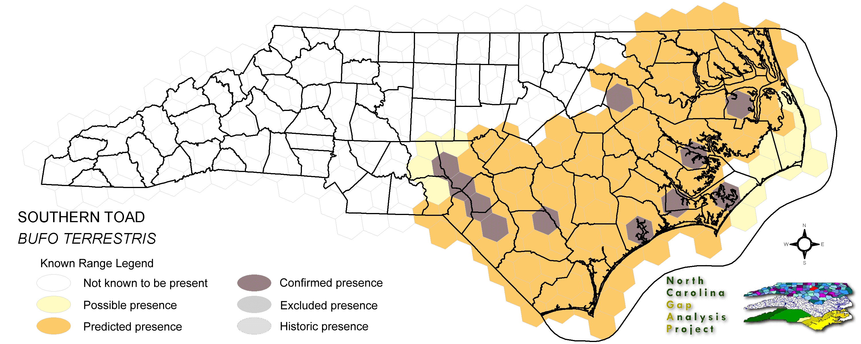
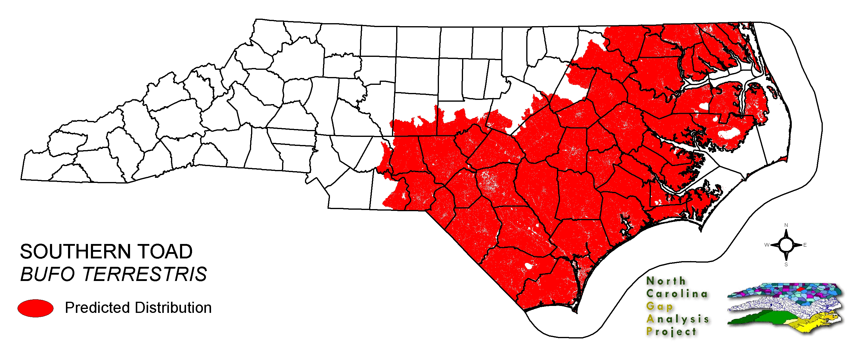
This species is found in a variety of wooded and unwooded habitats in the southern United States, including pine woods, sweet gum-willow oak, and maritime forests (Wilson 1995), though it seems to prefer sandy, friable soils (Martof et al. 1980). It requires shallow bodies of water for breeding (Martof et al. 1980, Conant and Collins 1998). Typically hides during the day often in self-made burrows (Conant and, Collins 1998). NATURE SERVE GLOBAL HABITAT COMMENTS: Adaptable and ubiquitous. Occupies a wide variety of wooded and unwooded habitats, which usually have sandy soil. Burrows underground when inactive. Eggs and larvae develop in shallow water of permanent ponds, woodland pools, and flooded depressions. |
| Code | Name | Description | NC Natural Heritage Program Equivalent |
| 124 | Maritime Scrubs and Tidal Shrublands | Coastal shrubs including wax-myrtle, swamp rose, alder, yaupon, and greenbriar. | Maritime Shrubs, Salt Shrub |
| 371 | Maritime Grasslands | Dune grass community consisting of sea oats and beach grasses. | Dune grass, Maritime dry grassland |
| 121 | Maritime Pinelands | Loblolly forests and woodlands of the outer coastal plain. | Estuarine Fringe Loblolly Pine Forest |
| 17 | Maritime Forests and Hammocks | Maritime forests and woodlands dominated by live or sand laurel oak. Estuarine Fringe forests dominated by loblolly pine. | Coastal Fringe Evergreen Forest, Maritime Deciduous Forest, Maritime Deciduous Forest |
| 126 | Interdune Wooded Depression Swamp | Includes swamps dominated by sweetbay and swampbay or dogwood dominated forests. | Maritime Shrub Swamp, Maritime Swamp Forest |
| 173 | Coastal Plain Riverbank Shrubs | Shrub dominated riverbanks, commonly dominated by willows and/or alders. | Sand and Mud Bar |
| 50 | Coastal Plain Mixed Bottomland Forests | Includes forests dominated by a variety of hardwood species, including sweetgum, cottonwood, red maple. | Coastal Plain Bottomland Hardwood (in part), Coastal Plain Levee Forest |
| 49 | Coastal Plain Oak Bottomland Forest | Bottomland forests dominated by deciduous oak alliances. Oaks represented can include swamp chestnut, cherrybark, willow, and/or overcup oak. Inclusions of loblolly pine temporarily flooded forests occur in patches. Hydrology is temporarily to seasonally flooded. | Coastal Plain Bottomland Hardwoods (in part) blackwater subtype, brownwater subtype |
| 158 | Coastal Plain Nonriverine Wet Flat Forests | Loblolly pine - Atlantic white-cedar - red maple - swamp tupelo saturated forests as well as forests dominated by loblolly, sweetgum, and red maple in non-riverine flats. | Non-riverine Wet Hardwood Forest |
| 41 | Peatland Atlantic White-Cedar Forest | Dense stands of Atlantic white cedar with saturated hydrology. Can include swamp tupelo, red maple, and pond pines with a moderate shrub and herb layer. | Peatland Atlantic White-Cedar Forest |
| 30 | Cypress-Gum Floodplain Forests | Swamps dominated by black or swamp tupelo with or without Taxodium. Seasonally to semi-permanently flooded hydrology. | Cypress-Gum Swamps |
| 78 | Pond-Cypress - Gum Swamps, Savannas and Lakeshores | Cypress dominated swamps and lakeshores. Can include bays dominated by pond cypress or shorelines of coastal plain lakes with a narrow band of cypress. | Non-riverine Swamp Forest, Natural Lakeshores (in part) |
| 385 | Oak Bottomland Forest and Swamp Forest | The swamp chestnut oak, cherrybark oak, shumard oak and sweetgum alliance is one representative. Other alliances are dominated by water, willow, and overcup oaks. Swamp forests can be dominated by sweetgum, red maple, and black gum being dominant. Loblolly can occur in combination with sweetgum and red maple, or with tulip poplar. Includes saturated and semi- to permanently flooded forests in the mountains. | Piedmont/Mountain Bottomland Forest, Piedmont/Mountain Swamp Forest |
| 63 | Coastal Plain Mesic Hardwood Forests | Beech dominated forests with white oak and northern red oak as possible co-dominants. Dry-mesic to mesic forests on slopes and small stream bottoms in the coastal plain. | Mesic Mixed Hardwood Forest, Basic Mesic Forests |
| 138 | Coastal Plain Dry to Dry-Mesic Oak Forests | Oak dominated forests of the coastal plain. Includes white oak forests with water oak or northern red oak and hickories as co-dominants. | Dry Mesic Oak Hickory Forest, Basic Oak Hickory Forest, Dry Oak Hickory Forest |
| 87 | Pocosin Woodlands and Shrublands | Includes pond pine woodland, low pocosin and high pocosin shrub dominated areas. Canebrakes and bay forests may be present. | Pond Pine Woodlands, Peatland Canebrake, Small Depression Pocosin |
| 67 | Wet Longleaf or Slash Pine Savanna | Wet flatwoods and pine savannas, typically dominated by longleaf pines, but slash or pond pines may be the dominant pines. | Wet Pine Flatwoods |
| 97 | Mesic Longleaf Pine | Longleaf pine woodlands without a major scrub oak component. Slash or loblolly pines may be present as well. | Mesic Pine Flatwoods |
| 42 | Xeric Longleaf Pine | Sandhills including a range of longleaf pine density from predominantly wiregrass, scrub oak dominated to true longleaf pine woodland. This does not include mesic or saturated flatwood types. | Xeric Sandhill Scrub, Pine/Scrub Oak Sandhill, Coastal Fringe Sandhill |
| 46 | Xeric Oak - Pine Forests | Mixed forest dominated by yellow pines with white or northern red oaks co-dominating. | Pine Oak Heath |
| 232 | Xeric Pine-Hardwood Woodlands and Forests | Mixed forest dominated by yellow pines with drier oaks including southern red, post, and chestnut oaks. | Dry Oak Hickory Forest |
| 267 | Riverbank Shrublands | Riverside shrubs with temporarily flooded hydrologies. Found in the both the Mountains and Piedmont. Containing dominants such as smooth alder and a Carolina or black willows. | Sand and Mud Bar |
| 269 | Floodplain Wet Shrublands | Saturated shrublands of the Piedmont, includes buttonbush, swamp-loosestrife, decodon and alders. | Piedmont/mountain Semipermanent Impoundment |
| 230 | Piedmont Mesic Forest | American Beech - Red Oak - White Oak Forests. | Mesic Mixed Hardwood |
| 384 | Piedmont/Mountain Mixed Bottomland Hardwood Forests | Includes temporarily to seasonally forests dominated by hardwood species. Hardwoods include sweetgum, red maple, sycamore which co-occur in a mosaic of bottomland and levee positions. Includes alluvial hardwood forests in the mountains. Hemlock and white pine may occur as inclusions, but are generally mapped separately. | Piedmont/Mountain Alluvial Forest, Piedmont/Mountain Levee Forest |
| 383 | Piedmont Mixed Successional Forest | Generally loblolly mixed with successional hardwoods. Sweetgum, tulip poplar and red maple are common co-dominants in these successional forests. | No equivalent |
| 228 | Piedmont Dry-Mesic Oak and Hardwood Forests | Primarily oak dominated forests, white oak is often dominant, with co-dominants including . Also represented by sweetgum and tulip poplar dominated forests. | Dry Mesic Oak Hickory Forest, Basic Oak Hickory Forest, Dry Oak Hickory Forest |
| 222 | Piedmont Dry-Mesic Pine Forests | Loblolly dominated forests resulting from succession following clearing. This type occurs on all moisture regimes following disturbance with the exception of the extremely xeric sites. | No equivalent |
| 382 | Dry Mesic Oak Pine Forests | Mixed forests of the coastal plain and piedmont. Includes loblolly pine with white, southern red and/or post oak and loblolly with water oak. On basic sites of the piedmont, eastern red cedar may co-occur with post, black, and blackjack oaks. | Dry Mesic Oak Hickory Forest, Xeric Hard Pan Forest, Chestnut Oak Forest, Dry Mesic Oak Hickory Forest, Dry Oak Hickory Forest |
| 220 | Piedmont Xeric Pine Forests | Dry to xeric pine forests dominated by Virginia pine, shortleaf pine or Eastern Red Cedar. | Pine Oak Heath |
| 226 | Piedmont Xeric Woodlands | Generally post and blackjack oak dominated woodlands. White ash and pignut hickory can be found in combination with Eastern red cedar on glades. | Xeric Hardpan Forest |
| 20 | Coniferous Regeneration | Regenerating pine stands. Predominantly loblolly pine, but slash and longleaf stands occur as well. | No equivalent |
| 21 | Coniferous Cultivated Plantation (natural / planted) | Managed pine plantations, densely planted. Most planted stands are loblolly, but slash and longleaf occur as well. | No equivalent |
| 51 | Deciduous Cultivated Plantation | Planted deciduous trees. Includes sweetgum and sycamore plantations. | No equivalent |
| 36 | Successional Deciduous Forests | Regenerating deciduous trees with a shrub stature. Commonly dominated by sweetgum, tulip poplars and maples. | No equivalent |
| 180 | Agricultural Crop Fields | Farm fields used for row crops. | No equivalent |
| 205 | Agricultural Pasture/Hay and Natural Herbaceous | Farm fields used for pasture grass or hay production, as well as old fields dominated by native and exotic grasses. | No equivalent |
| 202 | Residential Urban | Includes vegetation interspersed in residential areas. Includes lawns, mixed species woodlots, and horticultural shrubs. Vegetation accounts for between 20 - 70% of the cover. | No equivalent |
|
Blem, C. R. 1979. Bufo terrestris. Cat. Am. Amph. Rep. 223.1-233.4.
Wilson, L. A. 1995. The Land Manager's Guide to the amphibians and reptiles of the South. Chapel Hill, NC: The Nature Conservancy. Mount, R. H. 1975. The Reptiles and Amphibians of Alabama. Auburn University Agricultural Experiment Station, Auburn, Alabama. vii + 347 pp. Behler, J. L., and F. W. King. 1979. The Audubon Society field guide to North American reptiles and amphibians. Alfred A. Knopf, New York. 719 pp. Martof, B. S., W. M. Palmer, J. R. Bailey, and J. R. Harrison, III. 1980. Amphibians and reptiles of the Carolinas and Virginia. University of North Carolina Press, Chapel Hill, North Carolina. 264 pp. |
For more information please contact them at:
NC-GAP Analysis Project
Dept. of Zoology, NCSU
Campus Box 7617
Raleigh, NC 27695-7617
(919) 513-2853
www.basic.ncsu.edu/ncgap