
| Taxa: |
| Order: |
| Family: |
| Mammalia |
| Rodentia |
| Castoridae |
| NatureServe Global Rank: |
| NatureServe State (NC) Rank: |
| G5 |
| S5 |
| Federal Status: |
| NC State Status: |
| --- |
| --- |
| Land Unit |
| US Fish & Wildlife Service |
| US Forest Service |
| US National Park Service |
| US Department of Defense |
| NC State Parks |
| NC University System |
| NC Wildlife Res. Com. |
| NC Forest Service |
| NC Div. of Coastal Mgmt. |
| Local Governments |
| Non-Governmental Org. |
| Other Public Lands |
| Private Lands |
| GAP Status 1-2 |
| All Protected Lands |
| Statewide |
| Hectares |
| 13,015.44 |
| 68,480.37 |
| 23,380.29 |
| 18,143.82 |
| 8,637.48 |
| 1,178.28 |
| 18,203.58 |
| 1,325.28 |
| 652.41 |
| 2,822.58 |
| 3,148.83 |
| 661.05 |
| 1,402,760.25 |
| 60,501.09 |
| 157,154.34 |
| 1,562,409.66 |
| Acres |
| 32,161.85 |
| 169,218.65 |
| 57,773.94 |
| 44,834.35 |
| 21,343.67 |
| 2,911.59 |
| 44,982.02 |
| 3,779.82 |
| 1,612.14 |
| 6,974.75 |
| 7,780.93 |
| 1,633.49 |
| 3,466,295.39 |
| 150,006.40 |
| 388,841.74 |
| 3,861,302.58 |
| % of Dist. on |
| Prot. Lands |
| 8.3 % |
| 43.6 % |
| 13.6 % |
| 11.5 % |
| 5.5 % |
| 0.7 % |
| 11.4 % |
| 0.8 % |
| 0.4 % |
| 1.9 % |
| 1.9 % |
| 0.3 % |
| < 0.1 % |
| 38.5 % |
| ----- |
| ----- |
| % of Dist. on |
| All Lands |
| 0.8 % |
| 4.4 % |
| 1.5 % |
| 1.2 % |
| 0.6 % |
| < 0.1 % |
| 1.2 % |
| < 0.1 % |
| < 0.1 % |
| 0.2 % |
| 0.2 % |
| < 0.1 % |
| 89.8 % |
| 3.9 % |
| ----- |
| ----- |
|
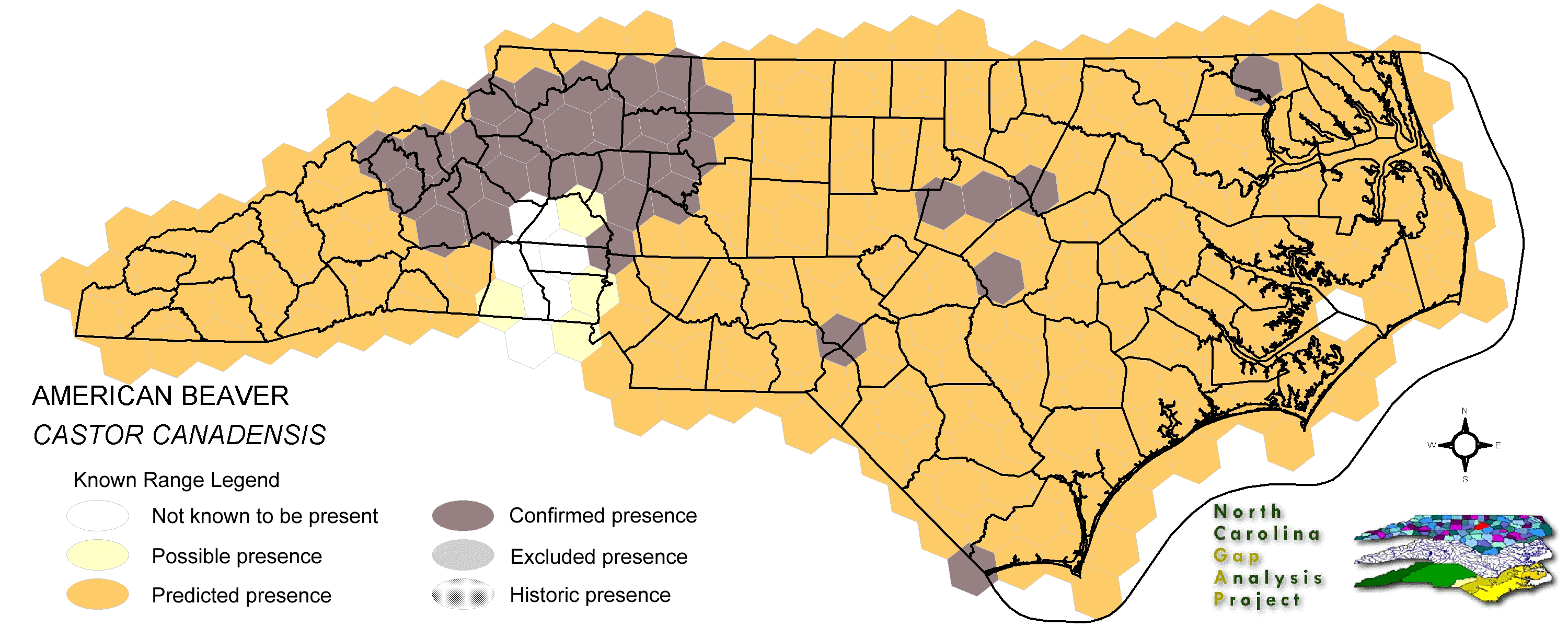
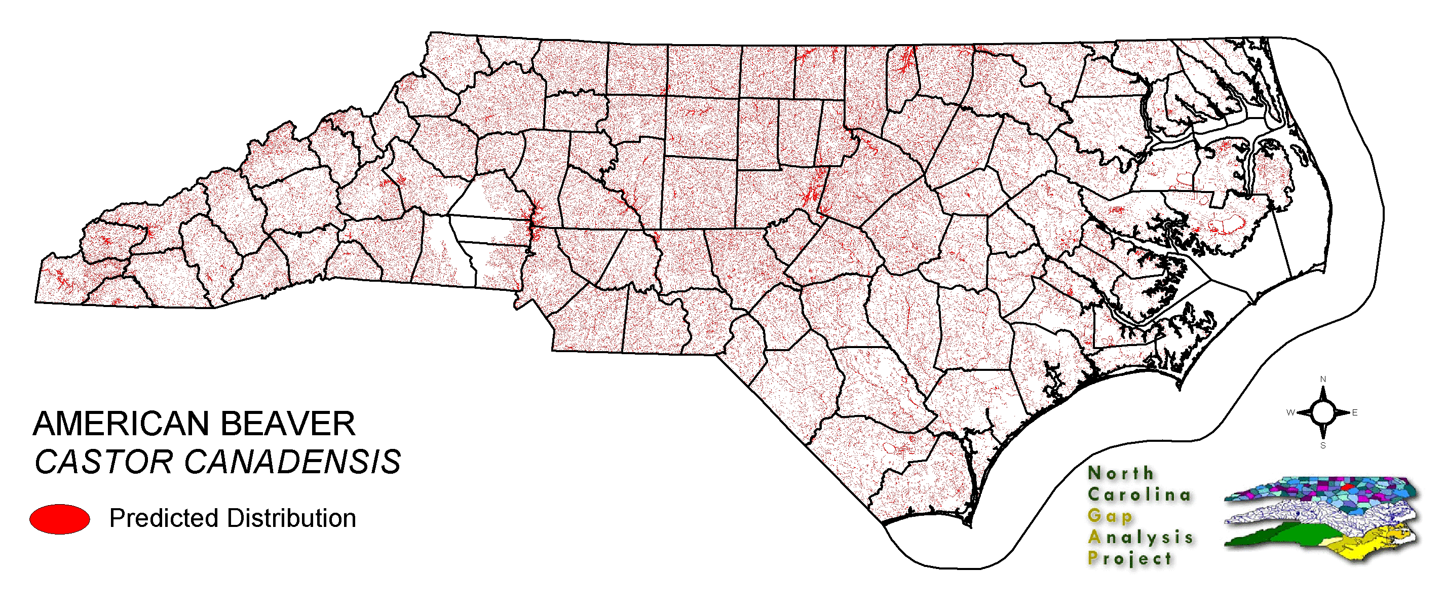
Though populations are sporadically distributed, beavers can populate areas quickly and become locally common anywhere in the state except the tidewaters (Lee et al. 1982, Webster et al. 1985). Beavers occupy small and medium-sized permanent water bodies in forested areas (Whitaker and Hamilton 1998). All manner of aquatic habitats that can be dammed to form calm pools and ponds are used. In larger still or slow flowing water bodies (lakes and rivers), beavers only build lodges or use burrows, dug by themselves or other animals into earthen banks at water's edge (Webster et al. 1985). In mountainous areas, beavers typically have most success at building ponds in valleys and flattened areas. Therefore, populations are more apt to be concentrated at lower elevations (Linzey and Linzey 1971, Whitaker and Hamilton 1998). However, they can be found far up the tributaries of mountain streams (Webster et al. 1985). Beavers rely on the inner bark, twigs and buds of nearby woody plants for food, harvesting these plant parts from shrubs near the ground or cutting down trees to gain access to them (Brown 1997). In doing this, they perpetuate early (seedling/sapling) successional stages of forest around their ponds. NATURE SERVE GLOBAL HABITAT COMMENTS: Beavers inhabit permanent sources of water of almost any type in their range, which extends from arctic North America to the Gulf of Mexico and arid Southwest, and from sea level to over 3400 m in the mountains. They prefer low gradient streams (which they modify; see below), ponds, and small mud-bottomed lakes with dammable outlets (Slough and Sadleir 1977, Beier and Barrett 1987, Novak 1987a, McComb et al. 1990). Beavers readily occupy artificial ponds, reservoirs, and canals if food is available. They generally avoid lakes with strong wave action and fast- moving streams. Waters with greatly fluctuating flow or water levels generally are poor habitat. In larger rivers (9th order or larger streams), beavers use floodplains and backwaters. In north-central Minnesota, one-third of the beaver families occupied bogs, two-thirds occurred in streams or lakes; most bog impoundments were at brushy minerotrophic sites (Rebertus 1986). Rebertus felt that beaver colonization of the bogs may have occurred when food supplies at lake sites were exhausted. In South Dakota, beavers depend on streamside riparian habitat for both food and shelter (Dieter and McCabe 1989). In the north, they require water that is deep enough such that it does not freeze to the bottom and allows the accumulation of a substantial food pile beneath the ice. Beavers are associated with deciduous tree and shrub communities. These may be either edaphic equilibrium communities (typically on alluvial soils and on hydric shorelines) or transient communities (usually following fires but also associated with windthrow, insect outbreak, and logging) (Slough and Sadleir 1977). Conditions that may make an area unsuitable or marginal for beaver include high stream gradient or inadequate food supply (e.g. see Beier and Barrett 1987), especially in winter (see section below on diet). In eastern Oregon, beavers selected areas with gentle bank slopes, low stream gradient, and abundant deciduous canopy cover; they did not build dams at sites with a rock substrate (McComb et al. 1990). In northern Minnesota, beavers appear to select optimal pond sites first, then flood more marginal areas as their population increases and resources are depleted (Naiman et al. 1988). In many situations beavers modify existing stream courses or other bodies of water and make them more suitable for their own use (see section below on dam building). They may occupy deep sections of streams and existing lakes or ponds without constructing a dam. In South Dakota, beaver preferentially occurred in areas where the riparian zone was ungrazed, providing plenty of small trees for food and building materials (Dieter and McCabe 1989). See Allen (1983) for a beaver habitat suitability index based on food and water characteristics. See Novak (1987a) for references to other models that have been developed in attempts to predict beaver family density. Dam Construction In many parts of the range, the first thing a beaver does when arriving in an area is begin building a dam (Remillard et al. 1987). Most dam building occurs April-June and especially August-October (Hill 1982), though repairs may be made at any time. All family members, except young in their first year, may assist in dam construction. More than one family group may cooperate in repairing a common dam (Schwartz and Schwartz 1981). The length and height of a dam may vary greatly, depending on the topography. In Quebec, the density of dams on small streams (4th order or less) averaged 10.6 per kilometer (range 8.6-16.0) (Naiman et al. 1986). In the northeastern U.S., a beaver family maintains an average of 2.5 dams. Generally trees, together with mud and rocks, supply the material for a dam. In some areas where trees are not available, shrubs (e.g. sagebrush) are used, though the resulting dam may be relatively weak. Some dams may be made mostly of rocks. Streams dammed by beavers typically are 2nd to 4th order streams; rarely do they build on 1st-order streams except at uncommonly high population densities. Dams in the main channel of streams of 5th order or larger often are destroyed by spring flooding (Naiman et al. 1986). In some areas (e.g. Missouri), dam building does not occur as commonly as in the north or west, perhaps due to the occurrence of deep swift rivers subject to severe flooding (Schwartz and Schwartz 1981). Dams typically are built across streams or at the outlet of a lake, but beavers also may dam seepage areas associated with bogs (Rebertus 1986). During periods of flooding due to heavy rains or snow melt, beavers may construct a spillway in the dam. Dam repairs apparently are stimulated by the sound of running water. In northern Minnesota, Johnston and Naiman (1990) found that during a period (1940-1986) of beaver population expansion and stabilization, 75% of the pond sites that ever were used were established in the first two decades of beaver colonization. Thereafter, creation of new ponds was constrained by geomorphology; ponds created after the first two decades averaged much smaller than those duirng the initial beaver population increase. (In 1986, at the end of the study period, beaver density was approximately one colony per square kilometer.) Lodges A characteristic beaver sign is the lodge, a hollow mound of tree branches (or, in the far north, mainly nonwoody material) and mud within which the beaver family sleeps and raises young. A lodge may be built against a bank, on an island, or in shallow water, but it must be near permanently deep water such that the entrance of the lodge is under water and so that the food cache can be reached even when the body of water is ice-covered. In bogs in northern Minnesota, beavers sometimes built lodges on the bog mat and many lodges were floating (Rebertus 1986). The walls of the lodge may be up to about two feet (60 cm) thick, with a thinner roof allowing for some ventilation. A family may maintain and use more than one lodge in summer in some areas (e.g., Colorado, Massachusetts). In some localities beavers use a different lodge each winter; it is more likely that the same lodge will be used if food in the area is abundant (Buech 1985). Along the Big Sioux River in South Dakota, all but 2 of 33 active lodges were built into river banks (Dieter and McCabe 1989). Beaver dens are not always in lodges. In some areas, beavers den in burrows in the banks of streams or lakes. This is common in areas subject to floods and fluctuating water levels. A den in a bank burrow is reached through a long tunnel 30-45 cm in diameter, with the entrance usually below water (Schwartz and Schwartz 1981). A den in a bank has a vent hole and a covering of sticks and mud (Novak 1987a). Bank burrows are more likely to be used at a natural pond or lake and along a large river (Hamilton and Whitaker 1979). In many areas both lodges and bank dens are used (Hill 1982). Missouri beavers may build lodges in marshes, lakes, or backwaters, but most burrow in stream banks (Schwartz and Schwartz 1981). In Texas, beavers burrow into cut banks of streams and lakes. Dens have one or more entrances. Beavers normally stay within 0.8 km of the den throughout the year (Schwartz and Schwartz 1981). Swimming and Diving Beavers usually swim relatively slowly at the water surface. If necessary, they can swim quickly underwater and may travel several hundred meters without surfacing. Maximum submergence time is about 15-20 minutes. |
| Code | Name | Description | NC Natural Heritage Program Equivalent |
| 17 | Maritime Forests and Hammocks | Maritime forests and woodlands dominated by live or sand laurel oak. Estuarine Fringe forests dominated by loblolly pine. | Coastal Fringe Evergreen Forest, Maritime Deciduous Forest, Maritime Deciduous Forest |
| 126 | Interdune Wooded Depression Swamp | Includes swamps dominated by sweetbay and swampbay or dogwood dominated forests. | Maritime Shrub Swamp, Maritime Swamp Forest |
| 380 | Coastal Plain Fresh Water Emergent | Emergent vegetation in fresh water seepage bogs, ponds and riverbeds of the coastal plain. Includes alliances dominated by sedges, eelgrass, as well as cane found in unforested cane-brakes. | Small Depression Pond, Sandhill Seep, Floodplain Pool, Unforested Floodplain Canebrake, Riverscour Prairies, Vernal Pools |
| 173 | Coastal Plain Riverbank Shrubs | Shrub dominated riverbanks, commonly dominated by willows and/or alders. | Sand and Mud Bar |
| 50 | Coastal Plain Mixed Bottomland Forests | Includes forests dominated by a variety of hardwood species, including sweetgum, cottonwood, red maple. | Coastal Plain Bottomland Hardwood (in part), Coastal Plain Levee Forest |
| 49 | Coastal Plain Oak Bottomland Forest | Bottomland forests dominated by deciduous oak alliances. Oaks represented can include swamp chestnut, cherrybark, willow, and/or overcup oak. Inclusions of loblolly pine temporarily flooded forests occur in patches. Hydrology is temporarily to seasonally flooded. | Coastal Plain Bottomland Hardwoods (in part) blackwater subtype, brownwater subtype |
| 158 | Coastal Plain Nonriverine Wet Flat Forests | Loblolly pine - Atlantic white-cedar - red maple - swamp tupelo saturated forests as well as forests dominated by loblolly, sweetgum, and red maple in non-riverine flats. | Non-riverine Wet Hardwood Forest |
| 41 | Peatland Atlantic White-Cedar Forest | Dense stands of Atlantic white cedar with saturated hydrology. Can include swamp tupelo, red maple, and pond pines with a moderate shrub and herb layer. | Peatland Atlantic White-Cedar Forest |
| 15 | Seepage and Streamhead Swamps | Includes extensive peat flats in the coastal plain, dominated by swamp tupelo, maples, and Atlantic white cedar alliances. In the sandhills includes streamhead pond pine and bay forests alliances. Saturated hydrology. | Bay Forest, Small Depression Pocosin, Streamhead Atlantic White Cedar Forest, Streamhead Pocosins |
| 30 | Cypress-Gum Floodplain Forests | Swamps dominated by black or swamp tupelo with or without Taxodium. Seasonally to semi-permanently flooded hydrology. | Cypress-Gum Swamps |
| 78 | Pond-Cypress - Gum Swamps, Savannas and Lakeshores | Cypress dominated swamps and lakeshores. Can include bays dominated by pond cypress or shorelines of coastal plain lakes with a narrow band of cypress. | Non-riverine Swamp Forest, Natural Lakeshores (in part) |
| 385 | Oak Bottomland Forest and Swamp Forest | The swamp chestnut oak, cherrybark oak, shumard oak and sweetgum alliance is one representative. Other alliances are dominated by water, willow, and overcup oaks. Swamp forests can be dominated by sweetgum, red maple, and black gum being dominant. Loblolly can occur in combination with sweetgum and red maple, or with tulip poplar. Includes saturated and semi- to permanently flooded forests in the mountains. | Piedmont/Mountain Bottomland Forest, Piedmont/Mountain Swamp Forest |
| 63 | Coastal Plain Mesic Hardwood Forests | Beech dominated forests with white oak and northern red oak as possible co-dominants. Dry-mesic to mesic forests on slopes and small stream bottoms in the coastal plain. | Mesic Mixed Hardwood Forest, Basic Mesic Forests |
| 138 | Coastal Plain Dry to Dry-Mesic Oak Forests | Oak dominated forests of the coastal plain. Includes white oak forests with water oak or northern red oak and hickories as co-dominants. | Dry Mesic Oak Hickory Forest, Basic Oak Hickory Forest, Dry Oak Hickory Forest |
| 87 | Pocosin Woodlands and Shrublands | Includes pond pine woodland, low pocosin and high pocosin shrub dominated areas. Canebrakes and bay forests may be present. | Pond Pine Woodlands, Peatland Canebrake, Small Depression Pocosin |
| 67 | Wet Longleaf or Slash Pine Savanna | Wet flatwoods and pine savannas, typically dominated by longleaf pines, but slash or pond pines may be the dominant pines. | Wet Pine Flatwoods |
| 97 | Mesic Longleaf Pine | Longleaf pine woodlands without a major scrub oak component. Slash or loblolly pines may be present as well. | Mesic Pine Flatwoods |
| 42 | Xeric Longleaf Pine | Sandhills including a range of longleaf pine density from predominantly wiregrass, scrub oak dominated to true longleaf pine woodland. This does not include mesic or saturated flatwood types. | Xeric Sandhill Scrub, Pine/Scrub Oak Sandhill, Coastal Fringe Sandhill |
| 46 | Xeric Oak - Pine Forests | Mixed forest dominated by yellow pines with white or northern red oaks co-dominating. | Pine Oak Heath |
| 232 | Xeric Pine-Hardwood Woodlands and Forests | Mixed forest dominated by yellow pines with drier oaks including southern red, post, and chestnut oaks. | Dry Oak Hickory Forest |
| 238 | Piedmont/Mountain Submerged Aquatic Vegetation | Seasonally to permanently flooded areas with aquatic vegetation. Waterlily, pondweed, hydrilla smartweed are a few of the species that can occur. | Piedmont/Mountain Semipermanent Impoundment (in part) |
| 239 | Piedmont/Mountain Emergent Vegetation | Emergent vegetation of all wetland hydrologies. Sites would commonly support species such as tussock sedge, rushs, and cattail alliances. | Rocky Bar and Shore (in part) |
| 267 | Riverbank Shrublands | Riverside shrubs with temporarily flooded hydrologies. Found in the both the Mountains and Piedmont. Containing dominants such as smooth alder and a Carolina or black willows. | Sand and Mud Bar |
| 269 | Floodplain Wet Shrublands | Saturated shrublands of the Piedmont, includes buttonbush, swamp-loosestrife, decodon and alders. | Piedmont/mountain Semipermanent Impoundment |
| 230 | Piedmont Mesic Forest | American Beech - Red Oak - White Oak Forests. | Mesic Mixed Hardwood |
| 384 | Piedmont/Mountain Mixed Bottomland Hardwood Forests | Includes temporarily to seasonally forests dominated by hardwood species. Hardwoods include sweetgum, red maple, sycamore which co-occur in a mosaic of bottomland and levee positions. Includes alluvial hardwood forests in the mountains. Hemlock and white pine may occur as inclusions, but are generally mapped separately. | Piedmont/Mountain Alluvial Forest, Piedmont/Mountain Levee Forest |
| 383 | Piedmont Mixed Successional Forest | Generally loblolly mixed with successional hardwoods. Sweetgum, tulip poplar and red maple are common co-dominants in these successional forests. | No equivalent |
| 228 | Piedmont Dry-Mesic Oak and Hardwood Forests | Primarily oak dominated forests, white oak is often dominant, with co-dominants including . Also represented by sweetgum and tulip poplar dominated forests. | Dry Mesic Oak Hickory Forest, Basic Oak Hickory Forest, Dry Oak Hickory Forest |
| 222 | Piedmont Dry-Mesic Pine Forests | Loblolly dominated forests resulting from succession following clearing. This type occurs on all moisture regimes following disturbance with the exception of the extremely xeric sites. | No equivalent |
| 382 | Dry Mesic Oak Pine Forests | Mixed forests of the coastal plain and piedmont. Includes loblolly pine with white, southern red and/or post oak and loblolly with water oak. On basic sites of the piedmont, eastern red cedar may co-occur with post, black, and blackjack oaks. | Dry Mesic Oak Hickory Forest, Xeric Hard Pan Forest, Chestnut Oak Forest, Dry Mesic Oak Hickory Forest, Dry Oak Hickory Forest |
| 220 | Piedmont Xeric Pine Forests | Dry to xeric pine forests dominated by Virginia pine, shortleaf pine or Eastern Red Cedar. | Pine Oak Heath |
| 226 | Piedmont Xeric Woodlands | Generally post and blackjack oak dominated woodlands. White ash and pignut hickory can be found in combination with Eastern red cedar on glades. | Xeric Hardpan Forest |
| 20 | Coniferous Regeneration | Regenerating pine stands. Predominantly loblolly pine, but slash and longleaf stands occur as well. | No equivalent |
| 21 | Coniferous Cultivated Plantation (natural / planted) | Managed pine plantations, densely planted. Most planted stands are loblolly, but slash and longleaf occur as well. | No equivalent |
| 51 | Deciduous Cultivated Plantation | Planted deciduous trees. Includes sweetgum and sycamore plantations. | No equivalent |
| 36 | Successional Deciduous Forests | Regenerating deciduous trees with a shrub stature. Commonly dominated by sweetgum, tulip poplars and maples. | No equivalent |
| 202 | Residential Urban | Includes vegetation interspersed in residential areas. Includes lawns, mixed species woodlots, and horticultural shrubs. Vegetation accounts for between 20 - 70% of the cover. | No equivalent |
| 8 | Open water | Open water without aquatic vegetation. | No equivalent |
| 517 | Hemlock Floodplain Forest | Alluvial forest with hemlock and/or white pine in mountains and western piedmont. Hydrology is generally temporarily to seasonally flooded. | Canada Hemlock Forest |
| 522 | Northern Hardwoods | High Elevation forests including yellow birch, American beech, and yellow buckeye. Includes forests with Hemlock and Yellow Birch. | Northern Hardwoods Forest, Boulderfield Forest |
| 525 | Appalachian Oak Forest | A variety of oak forest types including Black, White, Scarlet Oaks in dry to mesic situations. Includes forests historically co-dominated by American Chestnut. | High Elevation Red Oak Forest, Montane White Oak Forest |
| 526 | Appalachian Cove Forest | Mixed Mesophytic forests of the mountains. Includes tuliptree, basswood, yellow buckeye and surgar maple. This class is mapped to include cove forests dominated or co-dominated by hemlock. | Rich Cove Forest, Acidic Cove Forest |
| 527 | Appalachian Hemlock | Upland hemlock forests of the moutains region. Vary from side slopes to steep slope positions. | Canada Hemlock Forest |
| 528 | Appalachian Xeric Pine Forest | Pine forests and woodlands on xeric sites. A variety of pines, including Virginia, Shortleaf, Eastern White Pine, Table Mountain and Pitch pine. Often small areas of dense pine within a matrix of Xeric Oak-Pine Forests. | Pine Oak Heath |
| 529 | Appalachian Xeric Mixed Forest | Mixed forests with Virginia, Shortleaf, Eastern White Pine, Table Mountain and Pitch pines in combination with xeric oak species. Oaks include, white, Southern Red, black, and rock chestnut. | Pine Oak Heath |
| 530 | Appalachian Xeric Deciduous Forest | Deciduous forests in the mountains dominated by Xeric Oak species. Species include, white, Southern red, black, and rock chestnut. | High Elevation Red Oak Forest, Montane White Oak Forest |
| 533 | Appalachian Swamp Forest | Evergreen and deciduous forests with saturated hydrologies. This class may contain a variety of trees species, including hemlock - red maple, pitch pine, and white pine forests. | Swamp Forest-Bog Complex, Southern Appalachian Bog, Southern Appalachian Fen |
| 534 | Appalachian Wet Shrubland/ Herbaceous | Saturated shrubs and herbaceous vegetation. Often mapped as an inclusion in Appalachian Swamp Forest. | Southern Appalachian Bog, Southern Appalachian Fen |
|
Slough, B. G., and R. M. F. S. Sadleir. 1977. A land capability classification system for beaver (CASTOR CANADENSIS). Canadian Journal of Zoology 55:1324-1335.
Hill, E. P. 1982. Beaver. Pages 256-281 in J. A. Chapman and G. A. Feldhamer, editors. Wild mammals of North America:biology, management, and economics. Johns Hopkins University Press, Baltimore. 1147 pp. Naiman, R. J., C. A. Johnston, and J. C. Kelley. 1988. Alteration of North American streams by beaver. BioScience 38:753-762. Jones, J. K., Jr., et al. 1992. Revised checklist of North American mammals north of Mexico, 1991. Occas. Pap. Mus., Texas Tech Univ. (146):1-23. Wilson, D. E., and D. M. Reeder (editors). 1993. Mammal Species of the World:a Taxonomic and Geographic Reference. Second Edition. Smithsonian Institution Press, Washington, DC. xviii + 1206 pp. Brown, L. N. 1997. A guide to the mammals of the southeastern United States. University of Tennessee Press, Knoxville. xiv + 236 pp. Whitaker, J.O. Jr. and W.J. Hamilton, Jr. 1998. Mammals of the eastern United States. Cornell Univ. Press, Ithaca, New York. 583 pp. Dieter, C. D., and T. R. McCabe. 1989. Factors influencing beaver lodge-site selection on a prairie river. American Midland Naturalist 122:408-411. Lee, D. S., L. B. Funderburg Jr., and M. K. Clark. 1982. A distributional survey of North Carolina mammals. Occasional Papers of the North Carolina Biological Survey, No. 1982-10. North Carolina State. Mus. Nat. Hist., Raleigh, North Carolina. 72 pp. McComb, W. C., J. R. Sedell, and T. D. Buchholz. 1990. Dam-site selection by beavers in an eastern Oregon basin. Great Basin Naturalist 50:273-281. Linzey, Alicia V., & Donald W. Linzey. 1971. Mammals of the Great Smoky Mountains National Park. The University of Ten- nessee Press, Knoxville, Tennessee. 114 p. Hamilton, William J., Jr., and John O. Whitaker, Jr. 1979. Mammals of the eastern United States. Cornell Univ. Press, Ithaca, New York. 346 pp. Schwartz, Charles W., and Elizabeth R. Schwartz. 1981. The wild mammals of Missouri. University of Missouri Press, Columbia. 356 pp. Allen, A. W. 1983. Habitat suitability index models:fisher. U.S. Fish and Wildl. Serv. FWS/OBS-82/10.45. 19 pp. Rebertus, A. J. 1986. Bogs as beaver habitat in north-central Minnesota. American Midland Naturalist 116:240-245. Webster, W. D., J. F. Parnell and W. C. Biggs Jr. 1985. Mammals of the Carolinas, Virginia, and Maryland. The University of North Carolina Press, Chapel Hill, NC. Beier, P., and R. H. Barrett. 1987. Beaver habitat use and impact in Truckee River basin, California. Journal of Wildlife Management 51:794-799. Novak, M. 1987a. Beaver. Pages 283-313 in M. Novak, et al. editors. Wild furbearer management and conservation in North America. Ontario Ministry of Natural Resources. Obbard, M. E., et al. 1987. Furbearer harvests in North America. Pages 1007-1034 in M. Novak et al., eds. Wild furbearer management and conservation in North America. Ontario Ministry of Natural Resources and The Ontario Trappers Association. 1150 pp. Remillard, M. M., G. K. Gruendling, and D. J. Bogucki. 1987. Disturbance by beaver (CASTOR CANADENSIS Kuhl) and increased landscape heterogeneity. Pages 103-122 in M. G. Turner, editor. Ecological Studies 64. Landscape heterogeneity and disturbance. Sprin |
For more information please contact them at:
NC-GAP Analysis Project
Dept. of Zoology, NCSU
Campus Box 7617
Raleigh, NC 27695-7617
(919) 513-2853
www.basic.ncsu.edu/ncgap