|
| | | | | | | | | | |
 |
| |
|
Coachwhip
|
|
| Masticophis flagellum
|
| |
| ITIS Species Code: 174238
NatureServ Element Code: ARADB21020
|
|
| |
| |
Reptilia | | Squamata | | Colubridae
|
| | NatureServe Global Rank: | |
NatureServe State (NC) Rank: | | |
| | | Federal Status: | |
NC State Status: | | |
| |
|
|
|
| |
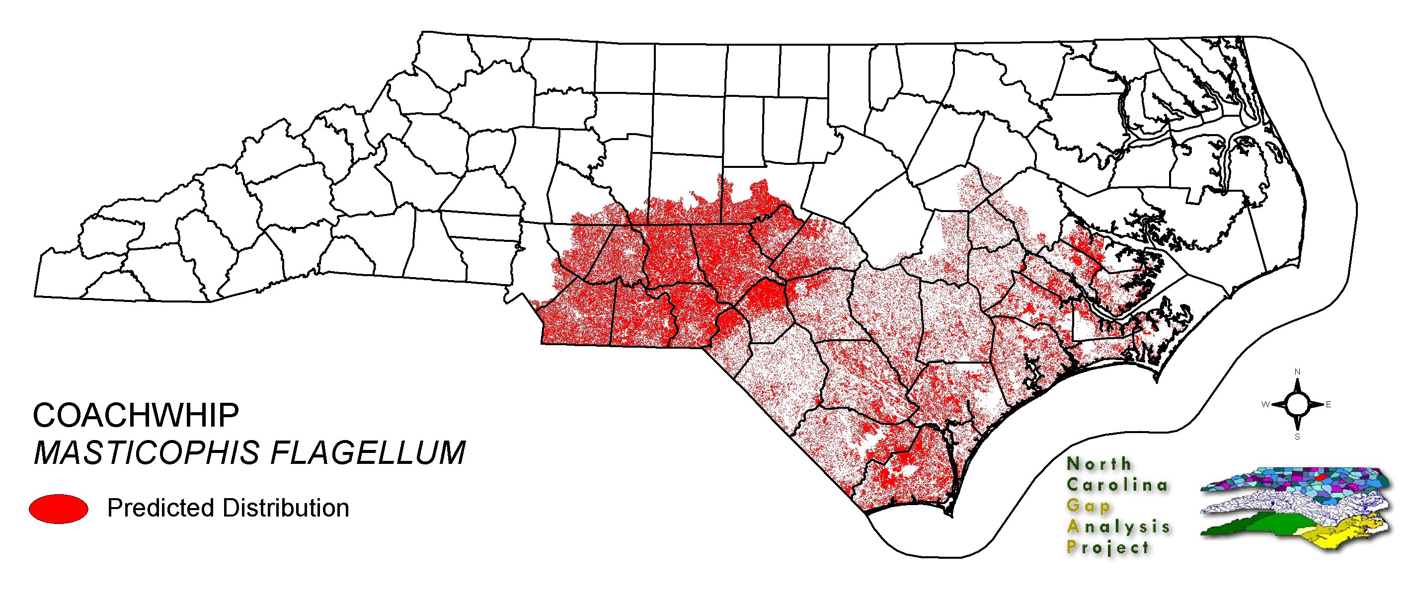
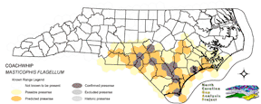
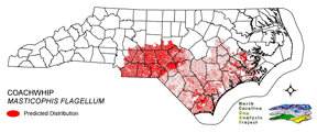
| HEXAGONAL KNOWN RANGE: | PREDICTED DISTRIBUTION: |
 |
 |
|
|
|
| |
| SUMMARY OF STATEWIDE PREDICTED DISTRIBUTION: |
| | | | Land Unit |
| | US Fish & Wildlife Service | | US Forest Service | | US National Park Service
| | US Department of Defense | | NC State Parks | |
NC University System | | NC Wildlife Res. Com. | | NC Forest Service | |
NC Div. of Coastal Mgmt. | | Local Governments | | Non-Governmental Org. | |
Other Public Lands | | Private Lands |
| | GAP Status 1-2
| | All Protected Lands | | Statewide |
|
| | | Hectares |
| |
2,480.22 | | 31,164.39 | | 73,085.76 | |
49.05 | | 4,371.12 | | 10,726.65 | |
23,189.94 | | 6,894.27 | | 3.15 | |
446.67 | | 2,491.38 | | 348.12 | |
1,725,501.78 |
| | 13,065.30 | | 154,002.87
| | 1,880,752.50
| | | | | Acres |
| |
6,128.76 | | 77,008.87 | | 180,598.81 | |
121.21 | | 10,801.27 | | 26,506.12 | |
57,303.58 | | 17,036.11 | | 7.78 | |
1,103.75 | | 6,156.33 | | 860.22 | |
4,263,806.93 |
| | 32,285.05 | | 380,549.31
| | 4,647,439.73
|
| | % of Dist. on |
| Prot. Lands |
| |
1.6 % | | 20.2 % | |
47.5 % | | < 0.1 % | |
2.8 % | | 7.0 % | |
14.5 % | | 4.5 % | |
< 0.1 % | | 1.6 % | |
1.6 % | | < 0.1 % | |
0.0 % |
| | 8.5
% | | ----- | | ----- |
|
| % of Dist. on | | All Lands |
| |
0.1 % | | 1.7 % | |
3.9 % | | < 0.1 % | |
0.2 % | | 0.6 % | |
1.2 % | | 0.4 % | |
< 0.1 % | | < 0.1 % | |
0.1 % | | < 0.1 % | |
91.7 % |
| | 0.7
% | | ----- | | ----- |
|
|
|
|
|
|
|
|
|
|
| |
| HABITAT DESCRIPTION: |
| |
NATURE SERVE GLOBAL HABITAT COMMENTS: Desert, prairie, scrubland, juniper-grassland, woodland, thornforest, farmland, creek valleys, swamps; usually in relatively dry open terrain. Terrestrial but also climbs into vegetation. Seeks cover in burrow, among rocks, or in vegetation.
|
|
| |
| MODELING DESCRIPTION: |
| Occupied Landcover Map Units: |
| | Code |
Name | Description |
NC Natural Heritage Program Equivalent |
| 97 | Mesic Longleaf Pine
|
Longleaf pine woodlands without a major scrub oak component. Slash or loblolly pines may be present as well.
|
Mesic Pine Flatwoods
|
| 42 | Xeric Longleaf Pine
|
Sandhills including a range of longleaf pine density from predominantly wiregrass, scrub oak dominated to true longleaf pine woodland. This does not include mesic or saturated flatwood types.
|
Xeric Sandhill Scrub, Pine/Scrub Oak Sandhill, Coastal Fringe Sandhill
|
| 46 | Xeric Oak - Pine Forests
|
Mixed forest dominated by yellow pines with white or northern red oaks co-dominating.
|
Pine Oak Heath
|
| 232 | Xeric Pine-Hardwood Woodlands and Forests
|
Mixed forest dominated by yellow pines with drier oaks including southern red, post, and chestnut oaks.
|
Dry Oak Hickory Forest
|
| 228 | Piedmont Dry-Mesic Oak and Hardwood Forests
|
Primarily oak dominated forests, white oak is often dominant, with co-dominants including . Also represented by sweetgum and tulip poplar dominated forests.
|
Dry Mesic Oak Hickory Forest, Basic Oak Hickory Forest, Dry Oak Hickory Forest
|
| 222 | Piedmont Dry-Mesic Pine Forests
|
Loblolly dominated forests resulting from succession following clearing. This type occurs on all moisture regimes following disturbance with the exception of the extremely xeric sites.
|
No equivalent
|
| 382 | Dry Mesic Oak Pine Forests
|
Mixed forests of the coastal plain and piedmont. Includes loblolly pine with white, southern red and/or post oak and loblolly with water oak. On basic sites of the piedmont, eastern red cedar may co-occur with post, black, and blackjack oaks.
|
Dry Mesic Oak Hickory Forest, Xeric Hard Pan Forest, Chestnut Oak Forest, Dry Mesic Oak Hickory Forest, Dry Oak Hickory Forest
|
| 220 | Piedmont Xeric Pine Forests
|
Dry to xeric pine forests dominated by Virginia pine, shortleaf pine or Eastern Red Cedar.
|
Pine Oak Heath
|
| 226 | Piedmont Xeric Woodlands
|
Generally post and blackjack oak dominated woodlands. White ash and pignut hickory can be found in combination with Eastern red cedar on glades.
|
Xeric Hardpan Forest
|
| 20 | Coniferous Regeneration
|
Regenerating pine stands. Predominantly loblolly pine, but slash and longleaf stands occur as well.
|
No equivalent
|
| 21 | Coniferous Cultivated Plantation (natural / planted)
|
Managed pine plantations, densely planted. Most planted stands are loblolly, but slash and longleaf occur as well.
|
No equivalent
|
| 205 | Agricultural Pasture/Hay and Natural Herbaceous
|
Farm fields used for pasture grass or hay production, as well as old fields dominated by native and exotic grasses.
|
No equivalent
|
| 60 | Sand
|
Exposed sand, predominantly in the sandhills region where disturbance or the extreme site conditions prevent natural regeneration.
|
No equivalent
|
|
| View Entire Landcover Legend |
| |
|
Additional Spatial Constraints: |
| Exclude all area outside of known range. |
| |
| CITATIONS: |
|
Wilson, L. D. 1973. Masticophis flagellum. Cat. Am. Amph.Rep. 145.1-145.4.
Secor, S. M. 1995. Ecological aspects of foraging mode for the snakes CROTALUS CERASTES and MASTICOPHIS FLAGELLUM. Herpetological Monographs 9:169-186.
Behler, J. L., and F. W. King. 1979. The Audubon Society field guide to North American reptiles and amphibians. Alfred A. Knopf, New York. 719 pp.
Hammerson, G. A. 1982. Amphibians and reptiles in Colorado. Colorado Division of Wildlife, Denver. vii + 131 pp.
Tennant, A. 1984. The Snakes of Texas. Texas Monthly Press, Austin, Texas. 561 pp.
Stebbins, R. C. 1985. A Field Guide to Western Reptiles and Amphibians. Second Edition. Houghton Mifflin Company, Boston, Massachusetts. xiv + 336 pp.
|
|
|
| 10 March 2005 |
| |
This data was compiled and/or developed
by the North Carolina GAP Analysis Project.
For more information please contact them at:
NC-GAP Analysis Project
Dept. of Zoology, NCSU
Campus Box 7617
Raleigh, NC 27695-7617
(919) 513-2853
www.basic.ncsu.edu/ncgap |