|
|
Taking Refuge-GAP a step further: The GAP Ecosystem Data Explorer Tool in the Roanoke-Tar-Neuse-Cape Fear Ecosystem
Steven G. Williams1, Casson Stallings2, JohnAnn Shearer3, and Alexa J. McKerrow1
1 NC Gap Analysis Project, NCSU, Raleigh, North Carolina
2 ManTech Environmental Technology, Inc., Research Triangle Park, North Carolina
3 USFWS Ecological Services, Raleigh, North Carolina
More and more land management agencies and conservation organizations are focusing their efforts on ecosystem conservation. In doing so, they've turned to Geographic Information Systems (GIS) to provide the analytical tools to look at landscape issues. The biological data developed by the Gap Analysis Program is an ideal dataset for these efforts. It was designed as such. However, the steep learning curve of GIS software and the cumbersome nature of spatial data has severely limited utilization of GAP data and GIS in general by the vast majority of people involved with land management. If GAP is to realize its full potential, it must make its data readily available and applicable to non-GIS trained biologists and land managers because that is where the largest impact can be made. In an effort to address that need, the University of Wyoming's Spatial Data and Visualization Center and the National GAP Program developed an ArcView based decision support tool designed specifically for US Fish and Wildlife Refuge managers called Refuge-GAP (Herdendorf and Crist, 1998). While scripting for the tool was not fully developed and was built around Wyoming data, the concept proved very attractive to another group of USFWS personnel halfway across the continent. Following a presentation of the North Carolina Gap Analysis Project (NC-GAP), biologists from the Roanoke-Tar-Neuse-Cape Fear (RTNCF) Ecosystem Team quickly seized on the idea of implementing GAP data through the use of a decision support tool based on Refuge-GAP. They saw such a tool as not just beneficial to Refuge personnel, but also to other USFWS offices including Ecological Services, Realty as well as their Ecosystem Planning Office. As a result, the USFWS and the National Gap Program provided funding to NC-GAP for further development of Refuge-GAP into the RTNCF GAP Ecosystem Data Explorer (GEDE) Tool.
Much like Refuge-GAP, the GEDE Tool is a customized ArcView (ver. 3.2) project that displays and manipulates GAP data through a series of dialog boxes and avenue scripts. The GEDE Tool allows non-GIS savey users to quickly view data and conduct advanced queries with a few simple clicks. While the GEDE Tool has been designed to be accessible to a broad audience, it is based on a full implementation of ArcView with Spatial Analyst, and thereby, provides an advanced GIS platform for those who wish to expand the complexity of their queries and analyses.
The GEDE Tool begins each session at a common starting point (figure 1). The user can then select an area of interest (AOI) by either importing a coverage or by creating one. Several methods of creating an AOI are presented including selecting features from standard coverages (e.g. quadrangles, counties, watersheds, refuges, etc.) or by direct onscreen digitizing (figure 2). Once a user has defined an AOI, the Tool queries the known ranges of all species to present only those species with a possibility of occurance within the AOI. The user is then presented with a series of choices designed to narrow the list of species. For example, the user can choose to continue with only federally or state listed species, high scoring Partners-In-Flight species, priority species as defined by The Nature Conservancy, species with a user-defined minimum percentage of their predicted distribution on highly protected lands or any combination thereof. Following that choice, the user is presented with a dialog box listing the selected species present which allows the user to display either their predicted distribution, known range or confirmed locations with a single click (figure 3). The user can also display the ownership, management or protection status of a species predicted distribution or view a species report, which contains information on taxonomy, habitat preferences, distribution modeling, literature citations as well as a quantitative summary of the areal extent of the predicted distribution by management agency throughout the ecosystem. The user can also choose to calculate a similar summary within just the selected AOI as well as select multiple species to create customized diversity maps.
FIGURE 1: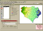
Click on image to get a better view |
FIGURE 2: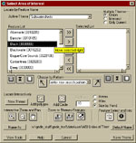
Click on image to get a better view |
FIGURE 3: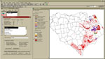
Click on image to get a better view |
Also built into the GEDE Tool is a spatial representation of the Land Acquisition and Prioritization System (LAPS) employed by the USFWS to prioritize lands for acquisition (realty.fws.gov/laps.htm). LAPS is designed to be an impartial score of conservation value based on four components: Aquatic and Wetland Resources, Landscape Conservation, Bird Conservation, and Endangered and Threatened Species. While not all scoring criteria used in LAPS are readily transferred to a spatial framework, we identified and created eleven spatial data layers representing various components and subcomponents that can be used as a spatial surrogate for LAPS (table 1). Once a user selects a Project Area and Landscape Effort polygon a twelfth layer is created based on their areal extents and is summed to the other eleven data layers to create the final LAPS data layer which is then displayed in the main view along with a dialog box which allows the user to select any of the 4 component or 10 sub-component data layers for display as well (figure 4).
FIGURE 4: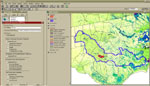
Click on image to get a better view |
The RTNCF GEDE Tool is distributed on a 2 CD set containing the customized ArcView project and all associated data necessary for implementation. Centralized scripting architecture (all variables are identified in a single script) and utilization of standardized GAP data format make the GEDE Tool readily applicable with other GAP data sets. You can find more information on the GEDE Tool by visiting the NC-GAP website at www.basic.ncsu.edu
The ease of use and accessibility of data make the GEDE Tool valuable to USFWS biologists and land managers as they set conservation priorities throughout the ecosystem. With its adaptable nature to other GAP datasets, it should prove a powerful tool beyond the RTNCF Ecosystem as well as beyond the USFWS.
LITERATURE CITED
Herdendorf, M. and P. Crist. 1998. Refuge-GAP: A GAP Decision Support System for Refuge Planning. Gap Analysis Bulletin 7:9-10 Laney, Wilson. 2001. US Fish and Wildlife Service. Personal Communication
Nelson, D. M., E. A. Irlandi, L.R. Settle, M. E. Monaco, and L. Coston-Clements. 1991. Distribution and Abundance of Fishes and Invertebrates in Southeast Estuaries. ELMR Rep. No. 9. NOAA/NOS strategic Environmental Assessments Division, Silver Spring, MD. 167 p.
U. S. Fish and Wildlife Service. 2000. Interim Land acquisition Priority System: Fulfilling the Promise. http://realty.fws.gov/laps.htm.
If you have any questions please contact Steve Williams at:
Department of Zoology, NC State University
Campus Box 7617
Raleigh, NC 27695-7617
(919) 513-7413 ph.
(919) 515-4454 fax
steve_williams@ncsu.edu