Introduction
The overall goal of this collaborative effort is to develop a consistent methodology and to enhance the capacity of states, joint ventures and other partners to formulate conservation design schemes at landscape levels to sustain bird populations and other wildlife in the Eastern United States. The initial project focused on the South Atlantic Migratory Bird Initiative landscape - namely, the South Atlantic coastal plain. While this project served as a "test of concept", subsequent projects have focused on refining the modeling protocols as well as expanding the working extent. The individual modeling componets of the DSL-SAMBI project has been fully documented on this website and can be accessed under the various headings provided above. As additional datasets are developed they will be added to the downloads page.
Objectives
1) Assess the current capability of habitats in ecoregions in the eastern United States to support sustainable bird populations. The project would develop and/or refine a set of bird-habitat models based on the Ecological Systems land cover and other habitat attribute data developed by Regional Gap Analysis and others representing major habitat types in ecoregions of the eastern United States. The set of species modeled would be derived partially from priority species and species-habitat suites from State Wildlife Action Plans and bird conservation plans. Success under this objective would be the completion of a set of species-habitat models and maps representing a broad range of habitats in a pilot ecoregion in the eastern United States that allow for estimates of the capability of that ecoregion (and state portions of that ecoregion) to support populations and the development of a consistent methodology using Ecological Systems data. The results of this analysis would allow for refinement of population and habitat objectives in State Wildlife Action Plans and bird conservation plans at state, ecoregional and, ultimately, continental scales. Methods and models will be developed in cooperation with partners from multiple ecoregions and will be directly applicable to the entire set of ecoregions covered by Eastern Regional Gap Analysis (see figure below) as those data become available.
2) Predict the impacts of landscape-level changes (e.g., from urban growth, succession, climate change and conservation programs) on the future capability of these habitats to support populations of migratory birds. The project would model predicted changes in land use and land cover patterns to predict changes in the capability of habitats to support priority populations. For example, one output of urban growth models is the pattern of habitat patches across the landscape showing loss, fragmentation and conversion of habitats due to urbanization and suburbanization. These outputs can be used in species-habitat models developed in this project to predict any reduction or change in capability of landscapes to support populations and, thus, be used to determine whether populations can be sustained at different levels of urban growth. We will be able to predict the benefits to populations from conservation programs such as the Farm Bill or North American Wetlands Conservation Act that protect, restore, enhance and manage habitats. When available, predicted impacts from climate change including changing vegetation patterns, hydrology and sea level also can be related to bird populations. Success under this objective would be the completion of predicted habitat maps and data under future scenarios and associated habitat and population capabilities data. These results will allow states and other partners the ability to conduct long-term planning to prevent species falling below critical thresholds.
3) Target conservation programs to most effectively and efficiently achieve habitat objectives in State Wildlife Action Plans and bird conservation plans and evaluate progress under these plans. Decision support tools would be developed using habitat data layers from Regional Gap Analysis and bird-habitat models to determine where conservation should be targeted to optimally achieve population objectives for migratory birds. These tools will allow managers to determine how to target and optimize habitat conservation for a single bird species, multiple bird species using similar habitats or multiple species using multiple habitats in a diverse, dynamic landscape using limited resources. These tools will allow managers to compare and evaluate the expected outcomes from potentially conflicting management alternatives benefiting some species but having negative effects on others (e.g., decisions about whether to manage an area as a grassland or shrubland). These tools will be developed with input from decision-makers and managers from state and federal fish and wildlife and land management agencies as well as NGOs and large private landowners. Success under this objective would be the development of a broadly applicable framework for decision models, and the creation of maps and other decision support tools in the pilot ecoregion that are used by partners in an adaptive management framework to make informed decisions about where to focus limited conservation dollars, manage land or programs for species with conflicting habitat needs and evaluate progress of habitat conservation relative to the plans. These tools will be developed in cooperation with partners from multiple ecoregions and will be applicable across the entire eastern United States as data becomes available.
4) Enhance coordination among the many partners, initiatives and plans that have initiated efforts to be more effective with planning, implementation and evaluation of habitat conservation through conservation design. Although there are a number of state and federal agencies, NGOs and other partners working on various conservation design tools in the eastern United States, there has never been an effort to link these efforts together using a consistent set of habitat and species data layers, models, maps and decision support tools. The completion of Southeast Regional Gap Analysis and initiation of Northeast Regional Gap Analysis (jointly referred to as Eastern Regional Gap Analysis) provides the first opportunity for the development of seamless, consistent map data layers and a consistent approach for developing decision support tools using these data layers. A consistent system would result in more coordinated planning, implementation, and evaluation within and among the eastern states, three existing or developing joint ventures (Atlantic Coast, East Gulf Coastal Plain and Appalachian Mountains) and numerous BCR planning initiatives. Success under this objective would be measured by enhanced coordination in the development and long-term use of these decision support tools by all states in the pilot ecoregion and coordination on the development of the framework with other states and key partners throughout the eastern United States.
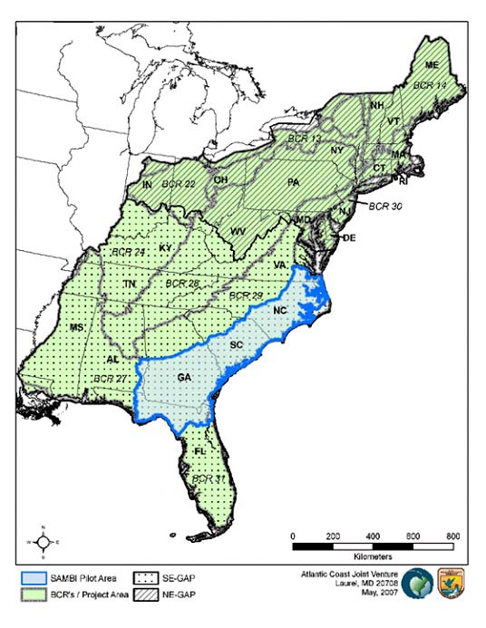 |
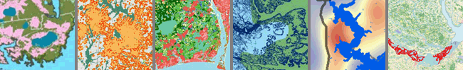
Project ExtentThe initial project will develop datasets and decision support tools for the South Atlantic Migratory Bird Initiative extent. This effort will provide a 'proof of concept' that can then be applied throughout the eastern US using the completed Gap Analysis Program datasets of the Southeast and Northeast regional projects.
|
 |
FundingFunding for this work is provided by the Multistate Conservation Grant Program administered through the Association for Fish and Wildlife Agencies. The initial grant provided $522,412 over a three year period beginning in January 2008. Additional support of $1.5 million is being provided in the form of Partner Funds - other ongoing efforts that directly support the objectives of the project. These consist of the USGS Gap Analysis Program's efforts in the Northeastern US, the USGS Pautuxent Research Lab's effort in the development of Inference Methods for modeling and ongoing logistical and coordination support from the Atlantic Coast Joint Venture. |
Key Cooperators
The primary cooperators include the USGS Cooperative Fish & Wildlife Research Units of North Carolina and Alabama and the Atlantic Coast Joint Venture. Much of the modeling of the landscape and avian populations will occur at the Biodiversity and Spatial Information Center located within the NC Cooperative Research Unit at NC State University. Researchers from the Alabama Cooperative Research Unit are developing both a Strategic Decision Making process for incorporating input from regional biologists and resource managers and the desicion support tools that will allow biologists and managers to assess the model outputs and develop conservation plans that are both efficient and foresighted.
