
| EDA Projects |
Our projects are diverse, including habitat management plans, protected area design, species recovery plans, and biodiversity assessment metrics. However, all our projects aim to ensure that local-scale conservation objectives, decisions, and measures of success are informed by landscape-scale patterns and processes. In addition, we are always seeking ways to better quantify and represent uncertainty in our models (e.g. untested assumptions of experts, natural temporal and spatial variability of ecological systems, data of poor quality or limited extent; unknown future conditions) to better facilitate management decisions and the allocation of monitoring and research efforts.
Project Summaries and ProductsJump to project of interest:
| |
|
Collaborative Conservation Design Project: Science Support for the South Atlantic Landscape Conservation Cooperative Conservation BlueprintBrad Pickens, Ashton Drew, Jaime Collazo, Louise Alexander-VaughnWe are providing science support, specifically conservation decision modeling expertise, to the SALCC team developing the regional conservation “blueprint.” SALCC intends the blueprint design to be more than simply a map of priority conservation areas given the current distribution of indicators. We will provide science support for design aspects that SALCC would like to research, evaluate, and potentially incorporate, such as (1) landscape modeling concepts that facilitate optimal prioritization of sites given changing land use, sea-level rise, and climate; and (2) decision theory concepts that facilitate meeting long-term objectives despite sort-term variability in conservation resources (e.g. funding), opportunity (e.g. land sales), and societal preferences. The incorporation of novel action-based selection criteria and time-to-action considerations into the Blueprint design would constitute a significant contribution to the science of conservation planning at this regional scale. |
|
Assessment of the South Atlantic Landscape Conservation Cooperative's Terrestrial IndicatorsAshton Drew, Jaime CollazoSALCC has developed a list terrestrial data products expected to serve as indicators to both guide landscape-scale, long-term natural resource conservation planning and to monitor the success of the plan as it is implemented. Selected through regional workshops and expert elicitation, these indicators are believed to broadly represent the critical ecosystem processes and components necessary to ensure the integrity of the targeted natural resources. However, often experts’ knowledge of correlations is based on field observations. Given differences in scale and data processing, experts’ field observed correlations do not always directly translate to similar correlations in mapped data. Furthermore, landscapes in SALCC are dynamic and it is not guaranteed that correlative relationships observed today will continue to hold under threat of climate change, land us change, and sea level rise. We are working closely with SALCC and NatureServe to (1) assess the correlation of the SALCC terrestrial indicators with other spatial ecosystem components (species and habitats), processes (fire, freshwater flow), and threats (land use change, climate change, and sea level rise); and (2) to propose alternatives to improve the terrestrial indicators, based on the assessment results. |
|
Vertebrate biodiversity of Christmas tree farms: A database and metrics to facilitate conservation partnerships in productive landscapesAshton Drew, Jaime Collazo, David Cobb (NCWRC)We propose to develop and empirically test a biodiversity metric for agricultural landscapes using Christmas tree agriculture as a case study, and in doing so, promote better understanding and stronger partnerships between conservation managers and agricultural land owners. Private lands comprise approximately 90% of the land holdings in North Carolina (McKerrow et al. 2006). Opportunities to engage private landowners in the management and conservation of the State’s fish and wildlife species therefore offer tremendous potential benefits. The challenge is to build effective partnerships with private landowners and land managers that minimize government imposed regulations or restrictions (NC WAP 2005). The project proposed herein is designed to meet that challenge, by providing Christmas tree producers, Extension staff, and WRC biologists with a tool that quantifies the impacts of alternative commercial agricultural production decisions on terrestrial vertebrate species. The end point of the metric is to inform the WRC and landowners about the possible influence their practices (positive, negative, neutral) may have on wildlife within and around agricultural fields. |
|
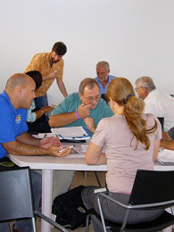
Strategic Conservation Planning for the Eastern North Carolina/Southeastern Virginia Strategic Habitat Conservation TeamLouise Alexander-Vaughn, Ashton Drew, Jaime CollazoThe Eastern North Carolina, Southeastern Virginia Strategic Habitat Conservation Team (ENCSEVA) is a partnership among local federal agencies and programs with a mission to apply Strategic Habitat Conservation to accomplish priority landscape-level conservation within its geographic region. ENCSEVA seeks to further landscape scale conservation through collaboration with local partners. To accomplish this mission, ENCSEVA is developing a comprehensive Strategic Habitat Conservation Plan (Plan) to provide guidance for its members, partners, and collaborators by establishing mutual conservation goals, objectives, strategies, and metrics to gauge the success of conservation efforts. We used the Open Standards for Conservation Design planning framework to provide a scientific foundation for the ENCSEVA conservation planning process. We elicited and summarized the expert knowledge of wildlife biologists, ecologists, hydrologists, researchers, natural resource managers, and conservation practitioners regarding five environments (wetlands, riverine systems, estuaries, uplands, and barrier islands) within the ENCSEVA geography. Specifically, our report describes: (1) the approach to elicit expert knowledge meant to support the strategic plan; (2) results of how this knowledge will inform collaborative conservation planning; and (3) a summary of opportunities available for the ENCSEVA team to address threats and impacts associated with climate change within the ecoregion. |
|
Hierarchical landscape models for endemic unionid mussels: building Strategic Habitat Conservation tools for mussel recoveryAshton Drew, Tom Kwak (USGS), Greg Cope (NCSU), Tom Augspurger (USFWS)The Southeastern US supports high diversity of freshwater mussels; however, many of these species are in decline due to impacts from multiple sources, including land use change, conflicting water resource demands, and pollution. Furthermore, changing temperature and precipitation patterns attributed to climate change are altering the aquatic landscape such that habitat suitable in the present may not be suitable in the future. We are developing a model that will support USFWS mussel population recovery and habitat management efforts within an adaptive management framework. Specifically, the model characterizes the habitat suitability and probability of occupancy of stream reaches in a manner that supports prioritizing among the following decisions: do nothing, protect habitat of existing population, restore habitat, translocate individuals, or release captive bred individuals. We use a variety of conservation planning and statistical modeling tools, including the Open Standards for the Practice of Conservation, Elicitator, and Bayesian belief networks to gradually move from modeling qualitative information to modeling quantitative information. We will present our procedure to construct and validate the models, which includes several cycles of knowledge elicitation, model development, and model review. (Abstract submitted to US-IALE, Newport, RI, Apr 2012) |
|
Extending the adaptive management frameworkKrishna Pacifici, Jaime CollazoAdaptive management has many meanings but commonly refers to situations in which there is uncertainty about how a system evolves over time and management strategies are designed to use new information as it becomes available. Strategies can be either passive, in which learning occurs but experiments are not conducted, or active, in which experimentation may occur to facilitate learning so better future decision can be made. More concretely adaptive management is generally framed in terms of Markov Decision Problems, which consist of a set of state variables, a set of actions, a probability distribution for future states given current states and actions and a reward function mapping current states and actions into benefits that the system generates. Often, however, there is uncertainty concerning either the probability or the reward functions. One approach to adaptive management assumes that there are a small number of alternative models, one of which is correct. The decision maker, however, does not know which is correct and instead makes decision based on a set of current belief weights associated with the alternative models. In applications of this framework to date the beliefs are updated using only the transition probabilities. This implies that updating of beliefs only uses observations of the state variables conditioned on the previous state and action. In many cases, however, other information is available that is relevant for the updating of belief. This information may take the form of some observable variables that impact the state transition or the reward function or could be observations that arise from research activities that are not directly related to the management problem. This type of uncertainty and learning can be incorporated into the adaptive management framework but to do so requires that new procedures be developed and software written that can provide solutions. This project aims to: 1) develop optimization approaches for strategic habitat conservation decisions in the context of the non-stationarity that characterizes climate and land use change, 2) revisit case-studies to address decision making and analytical (optimization) issues that need refinement, and 3) develop the supporting software to encourage the application of structured decision making and adaptive resource management by decision analysts across the U.S. and elsewhere. |
|
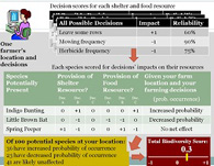
Vertebrate biodiversity in agricultural landscapes: predicting impacts of alternative row crop production strategiesAshton Drew, Louise Alexander, Jaime Collazo, Alexa McKerrow (USGS), John Alexander (NCSU)Increasing demand for food, fiber, and biofuels necessitates better understanding of the sustainability of alternative agricultural practices. We will present a tool we have piloted to inform commercial row crop producers (corn, cotton, wheat, and soy) of the relative expected biodiversity impacts of their operational decisions. Many vertebrate species inhabit the agricultural landscapes. Some are sensitive to certain operational practices (e.g. tillage, pest management, or field border management practices), while others are generally tolerant, and yet others may benefit. Species distribution data provided by the Southeastern Gap Analysis Program (GAP) predict potential species presence within the landscape based on characteristics such as habitat type and the spatial context of that habitat. With landscape influences already modeled, we focused on fine-tuning these predicted distributions based on how individual producers manage their agricultural lands. Through a series of elicitations, regional producers and wildlife biologists (1) identified operational decisions at the field and field border level that could impact terrestrial wildlife, and (2) characteristics of terrestrial wildlife species that make them likely to positively, negatively, or neutrally to those practice. We primarily focused on species shelter and food requirements and the likelihood of these resources being provisioned under alternative decisions. (Abstract submitted to US-IALE, Newport, RI, Apr 2012) |
|
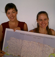
A structured approach to inform recovery decisions of the Antillean manatee in Puerto RicoJaime Collazo, Ashton Drew, and Louise AlexanderAntillean manatees (Trichechus manatus manatus) occurring in Puerto Rico are listed as an endangered species. Although little was known about the Puerto Rican manatee when listed in 1986, the US Fish and Wildlife Service and the Puerto Rico Department of Natural and Environmental Resources have implemented various recovery activities primarily focused on environmental education-regulatory efforts, habitat mapping, and monitoring. These efforts have provided important new data and insights regarding the manatee population of Puerto Rico. The U.S. Fish and Wildlife Service wished to capture this information in an updated recovery plan and in the design of manatee protected areas. We used the Open Standards for the Practice of Conservation, a qualitative framework rooted in adaptive management, to elicit expert and stakeholder knowledge to identify conservation objectives, key habitat characteristics, develop an understanding of project context, and to formally state hypotheses of how protected areas and conservation strategies will reduce threats. We found these methods well suited for organizing diverse knowledge resources into a coherent management vision with associated actions and helpful in the development of consistent and transparent processes to capture available knowledge, identify uncertainties, articulate expected outcomes to management actions, and facilitate the learning process central to adaptive management. We discuss the advantages of this method in light of agency objectives and remaining knowledge gaps regarding the species and causes of its decline. (Abstract from Sirenian International Symposium presentation, Tampa, FL, Nov 2011) |
|
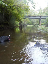
Science summary and recommendations in support of Manatee Protection Area design in Puerto RicoAshton Drew, Louise Alexander, Jaime Collazo, Jim Reid (USGS), Dan Slone (USGS)This project was designed to assist the US Fish and Wildlife Service’s Caribbean Field Office to identify and provide the scientific basis to propose Manatee Protection Areas (MPAs). Designation of these areas must comply with the legal definition of an MPA’s purpose: to prevent or reduce take of manatee (CFR 50: 44 FR 60964, Oct. 22, 1979). To meet this goal, we pursued two research objectives: 1) identify areas which include the specific ecological attributes necessary to support manatee populations, and 2) identify areas where take can be reduced through approved MPA regulatory frameworks. We achieved these objectives through literature review, expert elicitation, and geospatial modeling. The final product delivered to USFWS was a set of thirteen potential MPA regions. These regions represent experts’ hypotheses regarding manatee requirements and threats, and the potential to implement MPA strategies (e.g. watercraft access, speed regulations, signage and boater education). The thirteen regions were compared based on a number of factors, including their potential to reduce take, quality of the habitat encompassed, and total area encompassed. These regions serve as suitable starting points to reduce threats to manatees, but we recommend that before any is selected and established, hypothesized attributes and threats (i.e., boating activity) of MPAs are ground-truthed to visually confirm the local presence of resources, threats, and manatees. Once established, the effectiveness of MPAs should be monitored and updated through processes of adaptive monitoring and management. Aerial surveys, telemetry studies, and public surveys are all valuable tools to assess the success of an MPA. Establishing MPAs is a management action that, integrated within the species Recovery Plan, will enhance the conservation of manatees. (Abstract from Revised Draft Project Final Report, Dec 2011) |
|
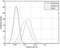
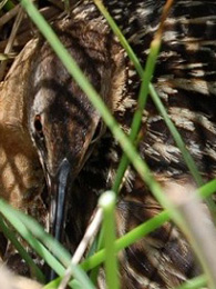
A Strategic Habitat Conservation approach to define and update local conservation objectives for a data-limited species: King RailAshton Drew, Jaime Collazo, Alexa McKerrow (USGS)Although Bayesian Belief Network (BBN) models have been promoted to the conservation community as models well-suited to support adaptive management strategies, there have been few tests of these claims. To test the value of BBNs to support U.S. Fish and Wildlife Service’ Strategic Habitat Conservation, we modeled habitat occupancy by breeding King Rail, Rallus elegans, in Eastern North Carolina and Southeastern Virginia. The regional absence of empirical data for this species, combined with its priority conservation status, made it an ideal candidate to explore strengths and weaknesses of an expert-based Bayesian modeling approach. Specifically, we evaluated whether BBN models initiated with expert knowledge and incrementally updated with empirical data could effectively support the definition of population and habitat objectives at regional and refuge scales. Following two years of field surveys, we compared occupancy predictions from the original expert-only BBN model, the updated expert+data BBN model, and empirically-derived detection-adjusted occupancy estimates calculated in the program PRESENCE. To interpret differences among these models, we evaluated the relative contribution of spatial data error, expert error, and uncertainty to model error. We conclude with specific recommendations for King Rail conservation and general recommendations to maximize the utility of expert knowledge within Bayesian Belief Networks designed to support adaptive management processes. (text from Draft Final Project Report, Dec 2011) |